Geographical location of Libya. Geographical location of Libya
Capital- Tripoli.
Time lags behind Moscow by 1 hour in winter, and by 2 in summer.
Square- 759.5 thousand km2
Population- 2.08 million people.
National language
Almost all Libyans speak Arabic, which is the official language of the country. Once widely used Italian language, especially among the educated layer of Libyan society. During the years of the British administration (1943–1951) it became widespread English language, which became especially popular with the advent of American and British oil companies in Libya.
National currency: Libyan dinar.
Religion:
With the exception of a very small number of Berbers who belong to the Ibadi or Kharijite sect of Islam, the Libyans are Sunni Muslims. Many residents of Cyrenaica are considered followers of the Senusite dervish brotherhood, a religious movement that spread to North Africa in the 18th century.
Geographical position
Socialist People's Libyan Arab Jamahiriya, a state in North Africa. In the north it is washed by the Mediterranean Sea, in the east it borders with Egypt, in the southeast with Sudan, in the south with Chad and Niger, in the west with Algeria and in the northwest with Tunisia.
Relief
The coastline of Libya in the central part of the coast juts deep into the land, forming the Gulf of Sidra (Great Sirte), where the barren desert approaches the Mediterranean Sea. In the northeast of the country is the higher and more populated plateau of Barka el Baida, which forms the core of Cyrenaica. In the northwest is Tripolitania, and in the south is the Fezzan depression, hundreds of kilometers from the coast.
Tripolitania. The Jefara coastal plain is developed here and contains several areas of irrigated agricultural land. However, even this most favorable for life and economic activity part of Libya is an arid sandy plain with sparse vegetation. To the south rise limestone hills and mountains with heights of up to 760 m, in places overgrown with bushes. There is sufficient rainfall here for the development of agriculture; Olives, figs and barley can be grown without watering. Further to the south, the mountains decrease and are replaced by the desert plateau of El Hamra, composed of red sandstones. In its northern part, nomadic tribes are engaged in cattle breeding. In the east, the plateau turns into the Es Soda Mountains (“black mountains”).
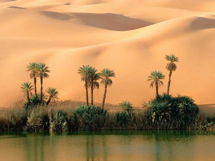
Fezzan. About 480 km south of Tripoli, the plateau descends to the Fezzan depression, composed of sands. There are several oases located here. Life depends on water supplies in wells and springs. To the southeast of the Fezzan the surface rises to a desert plateau, and along the southern border of Libya the high and dissected Tibesti plateau begins. Here is the highest point of the country - Mount Bette (2267 m).
Cyrenaica. The limestone plateau of Barqa el Bayda, located near Mediterranean coast, reaches a height of 910 m. The elevated parts of the plateau are overgrown with dense bushes, and remnants of forests are preserved there. There is sufficient rainfall to grow some crops, but the populated areas occupy a smaller area than in Tripolitania. To the south of the Barqa el Bayda plateau lies an extensive but lower sandstone plateau. Most of it, especially along the border with Egypt, is covered with sand dunes. This is the vast Libyan Desert. Oases are scattered on its western edge. The southernmost of them are the Kufra oases, located 800 km south of the Barqa el-Bayda plateau and approximately the same distance east of Fezzan. Between the oases of Kufra and the southern border of Libya, the desert stretches for 480 km.
Minerals
In 1988, when the last significant oil deposits were discovered in the country, the volume of oil reserves was estimated at 3 billion tons (first place in the world). The largest oil fields - Serir, Bahi, Nafura, Raghuba, Intisar, Nasser, Waha, Samakh - are located south of the Gulf of Sidra and are connected by oil pipelines to the coast. Oil for export is shipped through five oil tanker terminals located in the Mediterranean ports of Es Sider, Ras al-Anouf, Marsa al-Bureika, Marsa al-Khariga and Al-Zuwaytina. Libya ranks third in Africa in terms of natural gas reserves (657 billion cubic meters). The largest field is Khateyba (339 billion cubic meters). In 1970, a natural gas liquefaction plant was put into operation in Marsa el-Bureika, and in 1971 the export sale of liquefied gas began for the first time. In the early 1990s, new natural gas reserves were discovered in the Surt (Sirte) oil and gas basin.
Inland waters
There are no constantly flowing rivers, but there are significant reserves groundwater; where they are close to the surface, oases with fertile soils are located. There are many dry valleys - oueds, especially near the coast of the Gulf of Sidra, in Cyrenaica and Fezzapa. The only large bay is Sidra (Great Sirte).
Climate
On the coast of Libya the climate is Mediterranean subtropical, in the south it is desert tropical with sharp seasonal and daily temperature fluctuations and very dry air. The average temperatures of the coldest month - January - in the north of the country are 11-12 ° C, in the south 15-18 ° C, the temperatures of the warmest month - July - are 27-29 ° C and 32-35 ° C, respectively. In summer, daytime temperatures are above 40 –42° C, maximum – more than 50° C. In 1922, in Al-Azizia, 80 km southwest of Tripoli, a record heat 57.8° N. Coastal areas of the country receive the greatest amount of precipitation. In Benghazi the average annual precipitation is 250 mm, in Tripoli 360 mm. The nearby mountains and plateau of Barqa el Bayda are slightly more humid. Not far from them there are areas where less than 150 mm of precipitation falls per year. Rainfall on the coast occurs during the winter months, and summers are very dry and hot. The country's deserts often receive only 25 mm of precipitation per year. There are often hot, drying winds with dust storms - gibli and khamsin. Most of Libya, with the exception of certain coastal areas, mountains and oases, has an extremely dry climate and is unsuitable for agriculture.
Soils and vegetation
The coastline is dominated by subtropical semi-desert vegetation. Along the coast on gray soils and gray-brown soils there are rare acacias, sycamores, tamarisks, in more humid places there are thickets of maquis, groves of cedars, junipers. Between the coastal strip and the desert, wormwood, tough, low-growing grasses and shrubs grow. Vast areas of desert have almost no vegetation cover; Only rare shrubs, dry-loving thorny bushes and subshrubs, and solyanka are found.
Animal world
Libya's fauna is poor. There are many reptiles (snakes, lizards), rodents are abundant among mammals, and predators (jackal, hyena, fennec) can be found here. Antelopes live in the south. Insects are numerous. Birds are richly represented in the oases. Anchovy, mackerel, tuna, and horse mackerel are found in coastal waters.
National parks and attractions
Tripoli is a beautiful city, another name often used is "Arusa Al-Bahar Al-Mutawassat" or "The Bride of the Mediterranean". The old part of the city retains the appearance characteristic of many cities of the Arab East: low (one or two floors) houses with flat roofs, mosque minarets soaring into the sky, colorful and noisy oriental bazaars. In Tripoli itself and other places, ancient buildings erected by the Phoenicians, Carthaginians and Romans have been preserved. Note the Ahmad Pasha Karamanli Mosque, one of the most attractive ones built in the city. Located at the entrance to the central market, a short distance from the Palace, it was erected in 1711 by the founder of the Karamanli dynasty and governor of Tripoli, Ahmad Pasha. In the center, 25 domes crown its roof over a sanctuary decorated with magnificent stucco. A separate room is intended for the tombs of Ahmad Pasha himself and members of his family, and above it rises an octagonal minaret in a typically Turkish style. In-Naka Mosque (Camel Mosque) is the oldest mosque in Tripoli. Gurgi Mosque, built by Yusuf Gurgi in 1833, attracts the interest of many tourists for its elegant architecture. Its nine columns support a roof with sixteen small domes. The mosque's minaret, the tallest of all the minarets in Tripoli, is octagonal in shape and has two balconies. The Al-Jami Mosque, built by the Ottoman ruler of the country in 1640, is one of the recognized masterpieces of oriental architecture; its walls contain many interesting inscriptions. It is also called the "Great Mosque" of Tripoli. Other historical towns include Leptis Magna, 120 km away. east of Tripoli, Sirte, located 245 km. east of Benghazi, Sabratha - 60 km. west of Tripoli, and Gdames (“Pearl of the Desert”), located in a desert region 800 km away. south of Tripoli. Leptis Magna is an excellently preserved Roman city located east of the city of Al-Hum (Al-Homs) at the mouth of the Wadi Lebda River. It is possible that in old times it was an intermediate port on the Phoenician trade route in this part of the continent, and by the 6th century BC. e. was already ruled by Carthage. Among the most attractive in this city are the Arc de Triomphe of Septimus of Sèvres, the Forum, the Basilica with its ornamental designs and numerous sculptures, the semicircular Nymphaeum and the Baths of Hadrian. An elegant street with columns connects the Baths with the bay. Also of interest to tourists is the impressive 70-meter diameter amphitheater, which offers views of the city in all directions. Its stage and entrance openings have remained unchanged. The Roman Circle, on the eastern side of the city, is built in the shape of a horseshoe and exactly follows the line of the coast. Tolomea (Ptolomea) - the exquisitely decorated Hellenic Palace is the main attraction of this ancient city. The building dates back to the 1st century BC. e. with later ones, 1st century AD. e., extensions. This two-story house, with spacious rooms, mosaic floors and marble wall decoration, obviously belonged to a noble citizen. Monument Street, running from southwest to northeast through the northern district, was the main artery of the city and is therefore decorated along its entire length with fountains, porticoes, engravings and sculptures. The local Basilica has already been completely cleared of soil, as well as the building of the Duke's Headquarters, a fortress that once housed a Roman garrison. Siren - Temple of Apollo, one of the oldest buildings in the city, erected in the 7th century BC. e. with later additions being made over the next 300 years. Inscriptions with the names of the Roman priests of this temple can still be read on both sides of the entrance. At the main altar at the entrance there is still a drainage device through which the blood of sacrificial animals flowed. The Fountain of Apollo is located just behind the Temple. Right there, presumably by Emperor Troyan in 98 AD. e. The Great Baths were built, but after they were destroyed during Jewish pogrom, in 119 AD e. they were restored by Emperor Andrian. The building is interesting for its exquisite decorations, marble walls and floors, mosaics and amazing roof vaults. The Capitol, built at the end of the Hellenic period, was turned by the Romans into a temple where they prayed to Jupiter, Juno and Minerva. At its entrance rise four graceful Doric columns, and on them you can see Greek inscriptions left over from the time of Emperor Hadrian. Along the sides of the Caryatid Street, which runs east from the Agora, there were once many sculptures on pedestals. Now they lie on the ground and are irretrievably destroyed. On the street itself is the elegant house of Jason Magnus, one of the priests of the Temple of Apollo. Susa (Apollonia) is an old city wall, but it is in poor condition and is crumbling. Within the city walls are the Theatre, Baths, Main Street and the ruins of the Byzantine Palace. There are numerous churches scattered around, for example, the Church of the Double Walls, the Eastern Church of the 5th century AD. e. with several beautiful columns of green marble, the Central Church and the Western Church, built opposite the wall fortifications. In the center of the old town there is a small museum displaying some Byzantine mosaics and sculptures. In Libya there is quite a long and beautiful sea coast with excellent beaches, but most of them do not have modern recreation infrastructure. National Park Kuf.
Industry and economics
The Libyan government is making efforts to expand and diversify its industrial sector structure. New industries emerged in the early 1970s, including cement and metal products. In subsequent years, a number of contracts were concluded with Western European, Yugoslav and Japanese firms for the construction of several nuclear and thermal power plants, as well as heavy industry enterprises. It was envisaged that some of these enterprises would use crude oil as a raw material. Among the largest enterprises in the manufacturing industry are the metallurgical plant in Misrata, which produced up to 1.5 million tons of steel and rolled products in 1996, factories for the production of pipes and electrical cables; assembly of cars and tractors has been established. Light and food industries are poorly developed. Traditional industries include sponge harvesting, coastal salt evaporation and various handicraft industries such as leather, copper, tin, ceramics and carpet weaving. There are also small enterprises processing agricultural products, wood, paper, tobacco, textiles and soap.
The number of industrial workers is small, but is constantly growing as the oil industry develops and enterprises related to oil production and refining are built. Since almost half of the oil industry's workforce was made up of foreign workers, in 1971 the government encouraged foreign companies to hire as many Libyans as possible.
In addition to oil production, agriculture is an important component of the economy. The rural population cultivates the land in the narrow coastal strip of Tripolitania, using precipitation, and in summer - irrigation from wells. Around Tripoli, in the commercial horticulture area, citrus fruits, dates, olives and almonds are grown. In the southern oases, water from underground sources is used to irrigate fields. If there is sufficient rainfall, barley is cultivated on the periphery of the uplands. Arable land makes up only 1% of the country's area, and only 1% of it is under artificial irrigation. Since 1979, work has been underway on the construction of a “great artificial river” - a conduit designed to transfer water from 250 underground wells from the oases of Tazerbo and Sarir in the Sahara Desert to the coast of the country. By 1993, 1,800 km of pipelines and canals had been laid, roads and reservoirs had been built. In Cyrenaica, on the Barka el-Bayda plateau, cereals, olives and fruit trees. Libya has 8 million hectares of grazing land in Tripolitania and 4 million hectares in Cyrenaica. The El Akhdar Plateau region of Cyrenaica is home to nomadic pastoralists.
Holidays
1st of January - New Year, September 1 - National Holiday.
When compiling a description of the country, materials from the following sites were used:
http://www.krugosvet.ru/aMenu/1.htm
http://www.gold-pelican.spb.ru/countrys.php
http://tours.belti.ru/all_maps.php
http://www.oval.ru/encycl.shtml
The state of Libya is one of the most big countries African continent. Until recently, it had leading indicators economic development in the region, in addition, its history is full interesting facts. How did Libyans live before and how do they live now? A description of Libya, its attractions and legal system will serve as the subject of our story.
Geographical position
First, let's find out where the state of Libya is located. This country is located in the very north of the African continent. On the western side, its border runs with Tunisia and the Democratic Republic of Korea, on the south - with the state of Chad and the Sudanese Republic, and on the eastern side - with the Egyptian state. From the north, the shores of Libya are washed by the gentle waves of the Mediterranean Sea.
The territorial area of Libya is 1.8 million km2. Most of it is occupied by desert lands, in particular the Sahara Desert. Only in the north of the country is there a narrow strip of territory favorable for agriculture with a Mediterranean type of climate.
Among Libya's natural resources, oil should be highlighted first.
Story
To have a better understanding of the state of affairs in the present, you need to look into the past. Let's look at the main points of Libya's history.
In ancient times, its territory was inhabited by nomadic Berber tribes. The name "Libya" is of Greek origin. This is what the Hellenes called the entire African continent.
From the 1st millennium BC. e. active Phoenician and Greek colonization of the Libyan coast begins. During that period, such large colonies as Cyrene, Leptis Magna, Barca, Euchesparidae, and Tripoli arose. Many of these cities exist to this day and are major centers of the state of Libya.
In the second half of the 1st millennium BC. e. a significant part of the northern part of the country was captured by Carthage, the western part went to the Egyptian state of the Ptolemies. Nevertheless, by the beginning of our era, all these territories were controlled by the Roman Empire. After the fall of Rome, the east of Libya went to Byzantium, and the west to the barbarian state of the Vandals, centered in Carthage. However, in the 6th century AD. e., under Emperor Justinian, Byzantium managed to crush the Vandals and incorporate all their lands into its composition.
Throughout this time, the south of Libya was not subordinate to any state entity. Here, as before, free tribes roamed.
The situation changed radically from the middle of the 7th century, when the Arabs conquered Byzantine possessions in Africa. They also managed to conquer all of Libya, which was included in the Caliphate. Since then, the national composition of the country has changed significantly. If previously the majority of the inhabitants were Berbers, now the Arabs have become the dominant nation. After the collapse of the united Arab Caliphate in the 8th century, Libya was alternately part of the states of the Aghlabids, Fatimids, Ayyubids, Almohads, Hafsids, Ayyubids, Mamluks, until in 1551 it was annexed to the Ottoman Empire.

However, during this period Libya had relative autonomy. Since 1711, the Karamanli dynasty began to rule here, which recognized its actual dependence on the Ottoman Sultan. But in 1835, due to popular discontent, the dynasty fell, and the Ottoman Empire again established a regime of direct control of Libya.
In 1911, these lands were captured by Italy, having won the war with the Turks. From that time on, the country became an Italian colony. After the defeat of Italy during the World War in 1942, this territory was occupied by British and French troops.
In 1951, Libya became an independent monarchy led by King Idris I. Thus began recent history countries.
Era of Gaddafi
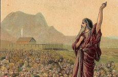
The person who had the greatest influence on modern history Libya, became Muammar Gaddafi. It was he who was the head of a conspiracy of officers directed against the monarchical power. In 1969, during the revolution, the power of Idris I was overthrown. The Libyan Arab Republic (LAR) was formed, led by Muammar Gaddafi. In essence, he was the president of Libya, although he never officially held this position.

In 1977, Gaddafi formally resigned from all government posts, retaining only the title of Brotherly Leader, but in fact continued to rule the state. At the same time, the LAR was transformed into the Jamahiriya. It was a unique form of government that proclaimed democracy, formally built on the governance of the country by many communes. The foundation of the Jamahiriya was socialism, Arab nationalism and Islam. It was in this ideological field that Libya found itself at that time. The head of state, Muammar Gaddafi, published the Green Book, which actually replaced the constitution.
It was during this period that Libya achieved unprecedented economic development. At the same time, the state’s relations with Israel and Western countries have become extremely strained, in which Libyan special services even carried out a number of terrorist attacks. The most famous of these was the plane bombing in 1988, after which economic sanctions were applied to Libya. In addition, he was accused of suppressing political opposition in his country and violating human rights, as well as aggression against some other African states.
Civil War
Naturally, this state of affairs did not suit a significant number of Libyans. In 2011, unrest began against the Gaddafi regime. When the confrontation between the rebels and government troops reached a particular intensity, the coalition intervened in the conflict Western countries, who took the side of the rebels. NATO aircraft bombed government military targets. With the support of foreign powers, the rebels managed to capture the capital of Libya, the city of Tripoli. Muammar Gaddafi was killed.

Libya began to be governed by the Transitional national council. But even after the parliamentary elections, peace did not come to the country. In it, a war continues between several opposing forces. Today, Libya is a virtually collapsed state entity. The state cannot ensure the unity of the country. In addition, the activities of a number of terrorist organizations have intensified in Libya, including the Islamic State (ISIS), which even managed to capture a number of territories.
Population
The overwhelming majority are Arabs, among whom there are many Arabized Berbers. The nomadic Berber and Negroid Toubou people also live in the south of the country.
The majority of the population is concentrated in northern Libya. The southern part of the country is sparsely populated, which is explained by the very dry climate of the Sahara. There are a large number of completely uninhabited areas.

The total population in the country is about 5.6 million people. It should be noted that of this number, most live in cities. For example, total number residents in the largest agglomerations settlements the countries of Tripoli, Benghazi and Misrata exceed 56% of the total population of the country.
Tripoli - capital of Libya
The capital of Libya is the city of Tripoli. It is located in the western part of the country on the Mediterranean coast. This is the largest of the cities for which the state of Libya is famous. The capital has a population of almost 1.8 million inhabitants. For comparison, the second largest city of the Libyan state, Benghazi, is inhabited by about 630 thousand people.
The city of Tripoli is very famous ancient history. It was founded back in the 7th century BC. e. and was originally called Ea. The modern name was given to the city a little later by the Greeks. Translated from Greek it means “Three Cities”. For a long time he was central city province of Tripolitania, and in 1951, after the country declared independence, it became the capital of Libya.

Now Tripoli is a large modern city with high-rise buildings and azure beaches, which the state of Libya can be proud of. Photos of sand dunes and dunes, which abound in information resources dedicated to the sights of corners of the globe, are fascinating, and it’s hard to even imagine that somewhere next to the wild desert nature there are high-rise buildings and... there is a war going on.
At the same time, despite its capital status, Tripoli is one of the largest government organizations There is only the Ministry of Foreign Affairs. All other bodies of the central government apparatus are concentrated in provincial towns. Even the parliament is located in the city of Sirte. This was done as part of a program dating back to 1988 to decentralize government in the country.
Political structure
At the moment, Libya is a unitary state. According to the form of government it is parliamentary republic. There is no such position as the President of Libya. The head of state is considered to be the chairman of the House of Representatives, who is elected by parliament. Since August 2014, this post has been held by Agila Sallah Isa. In addition, the House of Representatives (parliament) elects the prime minister of the country, that is, the head of the Government. At the moment, the head of the executive branch is Abdullah Abdurrahman al-Thani. The government is located in Tobruk. Abdullah al-Thani resigned several times, but remains to this day. O. Prime Minister.
At the moment, the State of Libya controls the eastern part of the country.
At the same time, it should be pointed out that in Tripoli there is a parallel General National Congress, which opposes the House of Representatives and controls the areas around the capital.
At the moment, Libya is a secular state with government bodies authorities are separated from religion and religious organizations. At the same time, Islamist sentiments are quite strong in society.

Administrative division
The state of Libya is administratively divided into 22 municipalities. True, this division is rather arbitrary, because the central authorities simply do not control a significant part of the country’s territory, and they actually have their own administrative units.
In addition, there are three historical provinces in Libya, from the union of which, in fact, at one time a single state was formed: Tripolitania, Cyrenaica and Fezzan. The centers of these unofficial components are, respectively, Tripoli, Benghazi and Sabha.
State symbols
Since 2011, the national flag of Libya has been a cloth with red, black and green stripes, located from top to bottom. In the center of the banner is an Islamic crescent with a star. This flag was used as the state flag during the Kingdom of Libya (1951-1969), but after the revolution it was replaced by Gaddafi with a red, white and black tricolor, and then, since 1977, with a completely green flag.
At the moment, there is no official coat of arms in the state of Libya, but there is a state emblem in the form of a yellow crescent and star.
The country's anthem since 2011 has been the composition “Libya, Libya, Libya,” which performed the same function during the monarchy. During the reign of Gaddafi, the musical work “Allah is Great” was used as an anthem.

Legal system
Currently legal system The state of Libya is based on French as well as Italian legal norms. At the same time, since the time of Gaddafi, the influence of Islamic law, in particular Sharia, remains quite strong.
The country has a Constitutional Court, although a new Constitution has not yet been adopted. At the same time, the state of Libya has not yet recognized the jurisdiction of international courts.
At the same time, it must be taken into account that at the moment different parts of Libya are controlled by several groups, so, in fact, the country does not have a single rule of legal law that would apply to the entire territory of the state. Many parts of the country have de facto strict Islamic law (Sharia).
Attractions
Ancient history has given us many cultural monuments that delight the eyes of tourists. Indeed, there are many historical places that the state of Libya can be proud of. Attractions are available in many regions of the country.
One of the most famous monuments of world culture located in Libya are the ruins of the amphitheater, which can be seen in the photo above. They are located in Sabratha, west of Tripoli. This amphitheater was built during Roman rule and was intended for spectacles that were supposed to entertain the public, including gladiator fights.

There are other ruins of ancient buildings of the Phoenicians and Romans throughout the country. Particularly famous among tourists are the ruins of the ancient city of Leptis Magna, founded by Phoenician colonists, but then adopted the Roman way of life.
Among the buildings of the Islamic period, the mosque of Ahmad Pasha Karamanli, located in Tripoli, built by this ruler of Tripolitania in 1711, can be especially highlighted. The Gurgi and Al-Jami mosques are also quite interesting.
In addition, rock carvings in the Tadrart-Akakus area, which are up to 14,000 years old, are included in the UNESCO World Heritage Site.
During the time of Gaddafi, the Jamahiriya Museum was especially popular among local residents and tourists.
Truly, the people of Libya have something to be proud of.
With faith in the future
From the moment of her birth, Livia experienced difficult periods. After the fall of the Gaddafi regime, many people were confident that bright times would come for real democracy and the rule of law. But their hopes were not destined to come true, as the country was mired in the abyss civil war, in which foreign powers also interfere to one degree or another.

Currently, Libya is actually split into several parts, which either demand broad autonomy from the central government or do not recognize it at all. At the same time, no one denies the right of the Libyan people to build a peaceful democratic society in which the supremacy of legal norms will be at the forefront. Of course, the Libyans will achieve this goal sooner or later. But when this will happen is the big question.
Today it is one of the fairly successful African countries. It is located in the north of the mainland. The area of the state is almost 1,760 thousand km 2. The capital is the city of Tripoli.
In the north, Libya has access to the Mediterranean Sea, making it the largest African country in the Mediterranean basin. It neighbors Egypt, Algeria, Tunisia, Chad and Niger.
Story
The country of Libya is a state whose history begins in ancient times. According to archaeological excavations, scientists have found that the sites of ancient people in this territory date back to the Neolithic era. In the ancient period of history, Libya passed from hand to hand and belonged to different time Carthage, Phenicia, Ancient Greece and Rome, Byzantium. In the 7th century it became part of the Arab Caliphate.
In the Middle Ages, in the 16th century it was captured Ottoman Empire. Since this period, Islam has spread throughout the country. Remained part of the empire until its collapse in 1911. Afterwards it became
A turning point in the state
The country gained its independence in 1951, becoming the United Kingdom. However, the king was overthrown in 1969 and the socialists, led by Muammar Gadafi, came to power, forming the Libyan Arab Republic. Later the state was renamed Jamahiriya ( masses). This is the name given to the territory of present-day Libya. In 2011, during political unrest and civil war, the population, with the help of dissidents and revolutionaries, overthrew the previous government led by Gaddafi. Since then, military clashes have constantly occurred here, which cannot be calmed down and now the country is in a state of civil war.

State name
The name of the country comes from the ancient dialect of the Berber tribes who lived in these territories. The first political association of people was called “Libu”, and later the state formed on these lands also became known as such. According to the rules for translating Arabic dialects into Russian, it would be correct to call the country “Libia”, but the previously established “Libya” remained normatively fixed.
Geographical characteristics
Libya today is 90% desert, although in earlier times there was much more vegetation. In the west, the relief rises slightly, forming the Idekhan-Marzuk and Aubari plateaus. Here is the highest point of the country - Bikku Bitti (2,267m). Closer to the coast, the desert recedes, leaving small area arable land. This area occupies only 1% of the entire territory, but provides food for Libya's needs. The coastline is indented, its length is 1,770 km. The largest bay is Sidra.

Climate
The climate of Libya, where the population suffers from unexpected changes in weather conditions, differs in the desert regions and on the coast. The desert has a dry, tropical climate, with characteristic sharp temperature fluctuations day and night. Average January temperatures in the desert are + 15°С…+18°С, in July +40°С…+45°С. Often this mark rises to +50°C. It is in the desert, not far from the capital, that the planet’s temperature maximum is +57.8°C. In the northern part of the state the climate is slightly milder - subtropical, Mediterranean type. The annual precipitation here is 200-250 mm. In the desert part, this figure decreases to 50-100 mm/year. In addition, dust storms (khamsin, ghibli) constantly blow in this territory. Most of the territory is unsuitable for agriculture. Due to climatic conditions, animals and vegetable world the country is very poor. Due to which the already small population of Libya suffers greatly - there is constant hunger.
Population of Libya
Despite the large territory of the state, only about 6 million people live in Libya. Most of the local residents gathered in the northern regions of the state, since living conditions here are milder in terms of climate. 88% of people live in the major cities of Benghazi. Libya is 50 people per 1 km 2. It is worth noting that this figure is quite small.
A characteristic feature of the population is that a third of the people living in Libya are children under 15 years of age. This inequality is caused by the fact that during the civil war in last years more than 50 thousand people died. adult population. Also, more than 1 million people emigrated from the country.

Nations
In respect of national composition Libya's population is homogeneous. Most of them are Arabs. Also in the cities there are Circassians, Tuaregs, and Berbers. They inhabit most of the territory of Libya. The population on the Mediterranean coast consists of a few communities of Greeks, Maltese, and Italians. They are mainly engaged in fishing. The official language of the state is Arabic. Sometimes Italian and English are found.
97% of the population professes Sunni Islam. Christianity accounts for just under 3%. Representatives of other religions also meet alone.
Administrative division and economic characteristics
Since 2007, Libya has introduced new system administrative division. The state is divided into 22 municipalities.
For a long time, the fate of Libya (the population has been suffering for several centuries) was not very successful. She was one of the planet, but by the 60s of the last century the situation had changed. It was during this period that the largest oil deposits were discovered on the territory of the state. Due to the fact that everyone was thrown into the development of the oil industry, the level of development of other industries dropped, and later they stopped developing altogether.
In addition to oil production, only agriculture is more or less developed in Libya, which only meets the needs of the local population.

The cultural level of development of the country is average. More than 90% of living people under the age of 16 can read and write. However, the population of Libya is gradually declining, because living here and getting higher education, including technical education, is quite difficult due to constant armed conflicts. All the country's funding goes to military support.
Located in the north of the African continent, in the north the territory of Libya is washed by the Mediterranean Sea. The relief of Libya is monotonous: 9/10 of the country's territory is occupied by the Sahara Desert, low plateaus 200-600 meters above sea level predominate, in the northeast and west they are replaced by low mountains (up to 1,200 meters), in the east of the country there are basins (about 130 meters below sea level). The country's only mountain range is the Tibesti Highlands on the border with Chad in the south of the country, where Libya's highest point, Bette Peak (2,286 meters), is located. Libya extends from north to south from 33°09′ to 19°30′ northern latitude at 1,504 km and from west to east from 9°23′ to 25°00′ east longitude at 1,538 km.
It borders Egypt to the east, Sudan to the southeast, Chad to the south, Niger to the southwest, Algeria to the west and Tunisia to the northwest. Length of borders: total - 4,348 km, with Egypt - 1,115 km, with Sudan - 383 km, with Chad - 1,055 km, with Niger - 354 km, with Algeria - 982 km, with Tunisia - 459 km. The length of the coastline is 1,770 km.
The total area is 1,759,540 km². As of February 2006, Libya did not officially own the waters, but the government claims a 12 nautical mile wide territorial sea and the Gulf of Sidra as historical waters.

Geographical location of Libya
The name of the country comes from the name of one of the local tribes - the Livu. The word "jamahiriyya" means "democracy". The capital of Libya is the city of Tripoli. The official language of Libya is Arabic. The state currency is the Libyan dinar = 1000 dirhams.
State of Libya is located in North Africa. In the north, Libya is washed by the waters of the Mediterranean Sea. In the east, the state borders on Egypt, in the southeast, Libya borders with Sudan, in the south it neighbors Chad and Niger, in the west it borders with Algeria, and in the northwest it borders Tunisia.
The area of the land states is 1.8 million sq. km. On the coast Libya climate Mediterranean subtropical, in the south - desert tropical with sharp seasonal and daily temperature fluctuations and very dry air.
Rain falls on the Libyan coast during the winter months, and the summers there are very dry and hot.

Representatives of flora and fauna
Flora in Libya very poor and meager. Deserts, which occupy 98% of Libya's total area, are almost devoid of vegetation. Date palms, orange and olive trees grow in the few oases.
In the mountainous regions of the state, juniper and pistachio trees are found.